Saturday, May 4, 2013

Prairie Des Mascoutins


Historical Marker on Trail at Junction of
US Route 24 and State Route 109
Photo Provided by Bob Morrison 
As I hike along the Old Towpath Trail- now known as the Buckeye Trail and The National Park Service’s North Country Trail- in Henry County Ohio, I am continually immersed in the scenic beauty of the natural surroundings. The glimpses of the State Scenic River, the bare woods, the musty scent of the damp earth finally unlocked from its frozen state, and the sounds of twigs and leaves snapping and crunching underfoot makes me appreciate winter’s yielding, and the promise of springtime emerging. Warmer temperatures ride the southern breezes that rattle and shake the barren timber canopy overhead, as if to say: “Wake you trees from your silent winter slumber!”

As I continue my hike, and appreciate the natural beauty of the Trail, I have also come to appreciate the rich history surrounding the Tow Path Trail, as teamsters once drew canal boats through the Miami & Erie Canal here with their teams of mules and Oxen. I can visualize Nineteenth Century life here that was centered on transportation and commerce around these canals- the “super highways” of their time.

Occasionally, I am reminded of more history which even predates the Canals! It is documented that the French were the first Europeans to explore this area. The Maumee River was a historical Trade Route used by the French. As the French traders and trappers explored this part of the continent in the 1600 and 1700’s, they came to discover that this river was part of a water transportation route connecting their settlements in Quebec with their settlements on the Gulf of Mexico- including New Orleans.

Traveling from Quebec by boat west up the St Lawrence River to Lake Ontario. Thence to Portage up Niagara Escarpment and around the Falls, all the way to the western end of Lake Erie. Thence entering the Maumee River (Miami of the Erie) and ascending it all the way to its headwaters near Kekionga- an Indian town (present day Fort Wayne, Indiana) Thence a brief five mile portage to the headwaters of the Wabash River. From here, traveling downriver clear until it empties into the Ohio River, then into the Mississippi River, and down to New Orleans. The entire distance by water- save 2 land portages totaling less than 50 miles!
Historical Marker at Junction of
US Route 24 and State Route 109
Photo Provided by Bob Morrison
So it is not a surprise that French and Native American settlements occurred here along the Trade Route known as The Maumee River. One such settlement was named “Prairie Des Mascoutins”. As I read the text on the front of the historical marker, I am so amazed to contemplate the events of those days, and the fact that here I stand over 250 years later on the same piece of ground! The text on the rear of the marker tells a yet more recent history as much armed conflict and strife occurred here as European settlement of the Maumee Valley unfolded. It was not a peaceful process, as the Native Americans, The French, The British, the New American Continental forces engaged in many conflicts in both the French & Indian Wars, and finally the second war of independence- The War of 1812. Not until the conclusion of the War of 1812 did the North Coast of the United States, and our Northern border become established. The Historical Marker here at this site bears witness to much of what happened here! Click here to
Read the Text of the Markers.

Contained in The Henry County Historical Society's Oral History Collection, is a transcript told by Genevieve Eicher- a Wyandotte Indian Decendant- as to the location of this settlement. Click Here to Read the Transcript of the Oral History narrative.

Wednesday, May 1, 2013

Butterflies on the Trail

The afternoon is oppressively warm and sultry; the air heavy with moisture- such as this late summer afternoon in August. The sun drentches my skin as I walk along the trail. There- up ahead in the shaded canopy of the giant trees- I  stop for a sip of water to quench my thirst and my parched disposition; a refreshing hydration. I wipe away the sweat from my brow. As I regain my composure from the exertion of walking in this heat, I gaze about.


Near the trail I see a small flower garden. In the flower garden are many beautiful annuals in full bloom. In all that blooming bounty, my view is filled with a sea of color as I marvel at all the beauty. In my admiration of all the floral wonders, I can't help but notice a visitor fluttering amongst all the fauna. I could tell the butterfly was excited to have found this delightful garden. She excitedly fluttered and floated from flower to flower. As she did, she feasted on the sweet nectar that each one had to offer. Landing on one flower and sampling it, then fluttering in indecision as she finally chose the next, and the next- a butterfly buffet!

Eventually she had received her fill, and decided to move on. What a treat to have shared a few brief moments with this visitor. I can't help but wonder if she so noticed my presence, as I noticed hers. I suspect not, but I cannot begin to know the cognitive nature of my fluttering friend. In any case, I reflected on my enigmatic encounter with this strange creature as I continued my late summer hike. Such a beautiful butterfly as I watched her flutter by.


Sunday, April 28, 2013

Kayaking the Maumee


Bob and Lou Ann Limbird of Napoleon, Ohio paddling around the north side of Girty's Island.

An increasing number of people are kayaking in the Maumee River. Kayakers can be seen along the Maumee River from the Henry County Park's Miami Wabash and Erie Canal Hiking Trail.  The canal was used from 1843 until 1913.  Kayakers can gain access to the Maumee river at Independence Dam State Park, Florida Ohio (at Independence Dam State Parks Parking lot next to the Florida Bridge), Napoleon Ohio's Meyerholtz Park and the boat docks at Ritter Park, as well as, Ohio's Mary Jane Thurston State Park's North Turkeyfoot Access just east of Henry County Road 6C.
Bob and Lou Ann Limbird on their Way from
Florida, Ohio to the Boat Docks at Napoleon's Ritter Park.
In 2006 the 21st Annual Maumee Valley Tri-Adventure race (sponsored by The Volunteer Connection of Northwest Ohio and The Naturalist Scouts) used the canal for a kayak/canoe race.  The 50-mile race consists of a 6-mile paddle, an 8-mile hike carrying 20 percent of a participate's body weight and ended a 35-mile bike ride.  Because of high water in 2006 the Maumee was not useable for the paddle canoe/kayak leg of the race.  The sponsors instead used the Miami Wabash and Eric Canal.  Competitors paddled from lock #13 at Independence Dam State Park to Gessner Park in the Villiage of Florida, Ohio.  The blogger at http://www.paddling.net/places/showReport.html?1386 reported high water in the canal made the use of the canal possible for the event.  Dead logs, vegetation and sandbars would have to be removed from the canal before canoes and kayaks could easily use the waterway. Share your kayak photos and stories on Facebook at Henry County Parks.  What is the make of your kayak?  Describe your kayak.  Where did you enter and exit the Maumee?  Any photos of your trip?  Be apart of the conversation.


Two kayaks racked on top and one inside the SUV leaving Napoleon Ohio's Meyerholtz Park river access

This article and photos submitted by Bob Morrison, Napoleon, Ohio

Wednesday, April 24, 2013

Underground Railroad On the Trail

Robert and Nancy Cole Newell home
Florida, Ohio

As you are walking or biking along the Miami Wabash and Erie Canal Tow Path Trail through Florida Ohio you will notice a greek revival house built between 1834 and 1838.   This site served as an  Underground Railroad Station.

Robert and Nancy Cole Newell bought the land in 1834.  Friends of  Freedom Society, Inc. and Ohio Underground Railroad Association say  the Newell's built their house around 1838.  It served as a trading  post and traveler's inn.  A jail was attached to the rear of the building.  Robert Newell had a blacksmith shop next to the home.  The home was an Underground Railroad Station for runaway slaves.  The fugitives were housed in the jail or, when the cells were full, were  sent across the street to the home of Dr. George Patterson or Dr. Parry.


Served as a trading post and traveler's inn

Nancy Newell often rode rode with the wagon driver when transporting  the fugitives.  The Miami, Wabash and Erie Canal was in operation  from 1843 until 1913. Occasionally Robert Newell would make arrangements with a canal boat captain to help transport the fugitives to Maumee. Robert often paid the fugitives to help him in the blacksmith shop. Nancy married Robert's cousin, Heman Newell after Robert's death.  They moved to Richland Township in Defiance County Ohio where they  also ran an Underground Railroad Station.  For more information and  photos go to  http://www.rootsweb.ancestry.com/~ohfulton/NewellUGRR.htm.

Article and Photos submitted by Bob Morrison, Napoleon, Ohio


Saturday, March 30, 2013

Historic Precht Bridge


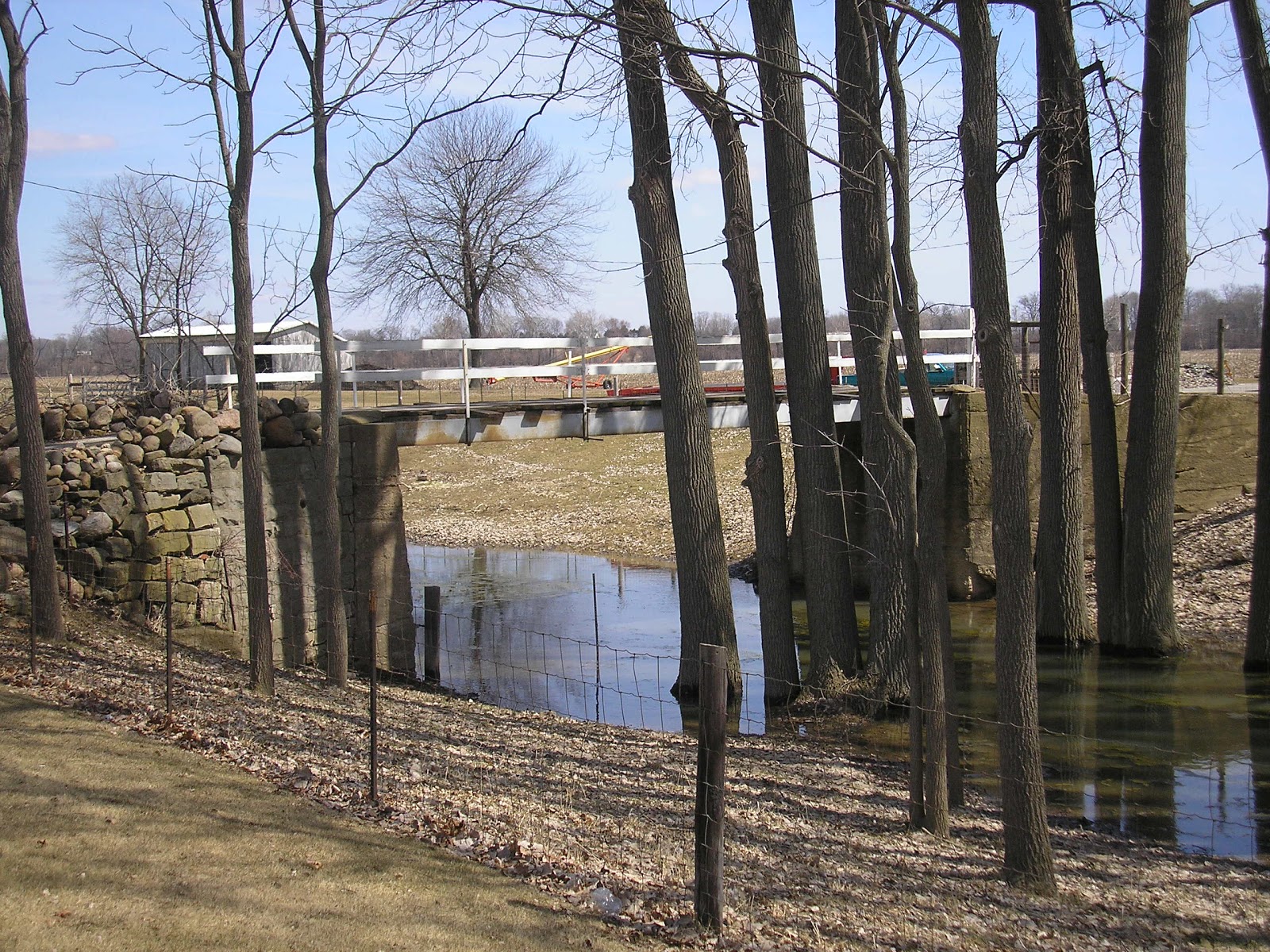
While Hiking along through Mary Jane Thurston State Park, North Turkeyfoot Creek Area, you will discover the Historic Precht Bridge. This is an old bridge which crosses the North Turkeyfoot Creek. It was from an old farm road from times long past. Legend has it that on old farmer named William Precht died here in a tractor accident. The old barn still stands on the north side of the creek. It is a great place to take a break from a long hike. Crossing the bridge from the North to the South, you can continue on the trail and eventually end up on the banks of the Maumee River.

Sunday, February 17, 2013

Ice House


Hiking the Buckeye Trail in Henry County Ohio I noticed a building at the edge of the Wabash, Miami and Erie Canal. It's probably an Ice House from about the early 1900's.  This  structure is between Florida and Napoleon, Ohio across the road from a turn of the century farm house. The first commercial ice household refrigerator wasn't available
until 1913 and then you had to have
electricity.

By the 1930s nearly  90 percent of the urban dwellers had electricity but only 10 percent of rural residents had access.
The Rural Electrification Act of 1936 provided federal loans for the installation of electrical distribution systems in rural areas.  The  Henry County REMC was incorporated in the spring of 1936.  
Nationally, within 2 years 1.5 million farms through 350 rural  cooperatives in 45 of the 48 states had electricity.


Before electrification, other people would have to buy their ice from commercial companies.   Jim Blount writes, "by 1811 their were 17 companies operating icehouse along the along the Miami and Erie Canal between LeSourdsville in Lemon Township and Port Union in West Chester Township north of Cincinnati".  One Cincinnati ice company owned 6 canal boats paying $30,000 in canal tolls in 1882.  Workers 
would saw ice block in canal retention ponds.  The ice was shipped by railroad, canal boat and paddle wheel boats.
 In a good winter blocks of ice stacked in an ice house could last a family ten or eleven months.  Straw and saw dust were layered between  the blocks of ice.

Click on the Facebook icon, "Henry County Parks"  and add your 
comments, stories or photos.

Photos and Narrative submitted by Bob Morrison, Napoleon, Ohio.


Monday, December 10, 2012

Unusual Structure

View of the Maumee River from the
Buckeye Trail in Napoleon, Oho
You can be alerted by email every time a new article is posted on this web site. Enter your email address under the phrase, " Follow us by Email" to the right of this article. Also join us on Facebook and share you photos taken while walking the Buckeye Trail through Henry County, Ohio. Clicking on, "Like us on Facebook" at the top right side of this web site I spotted an unusual structure while walking the Buckeye Trail between Meyerholtz Park and Ritter Park in Napoleon, Ohio.
 
Top View from the Buckeye Trail
Structure includes stone, cement,
nuts, bolts, and washers
The stone and cement structure is on the canal side of the trail. When was it constructed?  What purpose did this serve?  Who built it? The canal was in use from 1843 until 1913.  Wabash and Erie Canal began operation from the Ohio River (through Indiana and Ohio) to Lake Erie in the summer of 1843.  In 1828 the Indiana General  Assembly approved the borrowing of $200,000 to begin construction. Construction on this canal began in 1832.
 
The Erie Canal, running through the state of New York, created the first demand for cement to be imported to the US.  The first recorded shipment of Portland Cement to the US was in 1886.  In 1871 the first Portland Cement Plant was established in Coplay, Pennsylvania.  Cement was used to construct a lock near Defiance, Ohio in 1906. Before that time many of the locks were constructed of stone or wood.

Note the indentation down the right side
I can not find pictures or articles about this structure in books and    articles discussing canal construction. The Miami and Erie Canal joined the joined the Wabash and Erie Canal  at Junction, Ohio (just south of Defiance, Ohio) after the Wabash and  Erie canal was in operation.

The e-Book, Canal Fever, by Lynn Metzger described how the, "Ohio 
State Legislature had secured permission to link up with (and essentially appropriate) a segment of Indiana's existing "Wabash and Erie Canal" from Junction, Ohio to Toledo.
A good look at the bolt, washer, and nut assembly.
The last eighty-six miles completed the Miami and Erie Canal without digging more dirt.  The Ohio Board of Public Works proclaimed, "for the sake of convenience," the resulting composite waterway would be call the Miami and Erie Canal." The Miami and Erie Canal was completed thirteen years after  the completion of the Ohio and Erie Canal in Eastern Ohio. Looking across the canal.  No such structure can be seen on the other  side of the canal.


I find it interesting that formal education for civilian engineers  was unknown in the United States when the canals were built in Ohio. People in charge of building the Ohio canals prepared themselves by apprenticing on New York’s Erie Canal.

Post your answers on the Facebook Page, clicking on, "Like us on  Facebook" at the top right side of this web site.


Article and Photos submitted by Bob Morrison, Napoleon, Ohio.
 

Saturday, December 8, 2012

A Winter Odyssey on the Trail


Today I venture out walking after the heavy snows from last week. As cabin fever sets in, I love to get outdoors to chase it away! The snow is abundant from two major storms last week… one was expected, and one surprised us all – even the weather forecasters. I am bundled up in winter attire and walking down onto the Miami & Erie Canal Towpath Trail in Western Henry County, just east of the Village of Florida. The trail is part of the US National Park Service’s “North Country Trail”. Arriving on the trail I am completely intrigued. As often as I frequent the trail in other seasons, I am seldom here in Winter. The setting takes on a completely new and refreshing ambiance. The giant trees and dense underbrush-once teeming with growth and leaves now stand naked yet draped with snow in their silent slumber. On one side of me is the Maumee River- frozen solid with ice nearly two feet thick, on the other side is the Miami & Erie Canal. The sky overhead looms with grey and is heavily overcast. The air is still and weighs heavy with dampness. From indoors it may seem dreary, but outdoors on the trail, the grayness takes on a magical and mystical quality. I am standing in snow up to my knees. I am the first to walk on this trail through all this snow, as I trudge through the knee deep virgin powder. It’s refreshing how quiet and serine it is here. There is nearly complete silence. All the snow on the ground and the trees acts like a giant sponge, absorbing and muffling all the sounds. Occasionally I hear a dog bark in the distance, but that too is muted and silenced by the abundant snow. It is difficult as I continue walking through the deep powder. I must lift my feet very high with each step to overcome the depth of the snow. As I stop to catch my breath and snap some photos, I begin to feel the cold settle in. Winter’s Chill is invigorating, yet I must respect this force of Nature. I must keep moving to generate warmth for my body so it does not succumb to the forces of the ambient cold. If I were to stay down on the trail for any length of time, I would scout a place out of the wind to start a fire for warmth. Knowing I will return home shortly, I dismiss that notion and keep moving. As I strain sinking in this knee-deep powder, I can immediately see how snow-shoeing here would enable me to walk farther. The oversized shoes would prevent me from sinking into the snow, Next time I will bring snow shoes, but as I return to my world off the trail, I am re-invigorated, and my cabin fever is no more.

Wednesday, December 5, 2012

Autumn along the Trail

Hiking on the North Country/Buckeye Trail
in Henry County, Ohio
I love to hike on the trail in the Fall ! The Kaleidoscope of fall colors is all around and seems to be more vivid when the sun's rays illuminate the beautiful gold, amber, orange and red hues. As each day passes, it becomes a new and different spectacle to behold. As I walk along, my skin beeks in the warming yet waning sun of this fine October afternoon. It warms the morning chill off the crisp air, as it continues its perennial journey closer to the the southern horizon. Leaves crunch under foot as I walk, and the gentle afternoon breezes swirl among the trees, cascading many leaves through the air as they float to the ground.


Florida Spillway
The cooler temperatures make hiking enjoyable, and the small animals are more active. Squirrels scurry about with their Herkey-Jerkey movements as they work to gather food for their long winter's rest. The flocks of Canadian Geese gather in the wetlands along the canal as they take a brief respite from their long journey south for winter. Listening to their honking as they fly south in their V-Shaped formation overhead is a special treat I love to watch. 
Beautifull Fall Foilage

I enjoy my hike, for I know that it won't be long until all the leaves have fallen, and the giant trees have yielded to Winter's Silent Slumber. Occasionally the scent of burning leaves drifts by. It is a familiar scent this time of year. It makes me think of crisp juicy apples and fresh-squeezed cider for which their was ample bounty this year! I will remember this day as a gem, and as the days continue to get shorter as we coast into the holiday season, I will have this day to remember throughout the long cold winter ahead.

Thursday, August 9, 2012

Hovercrafts along the trail


The other day while walking on the Miami, Wabash and Erie Canal towpath I saw three hovercrafts coming up the Maumee River. 


Two Hovercrafts waiting for a friend

Eight hovercrafts from Indiana, Kentucky, Michigan and Ohio explored the Maumee July 21@22. The club members first went from Waterville to Grand Rapids. Got out at Grand Rapids. The next day they put in at the Mary Jane Thurston State Park boat ramp and sped up the Maumee to Napoleon's Ritter Park boat ramp.


Mike McFarrlane of Adrian Michigan worked three nights a week for
eight months to build his hovercraft.


Mike McFarrlane came up the Maumee at speeds as high as 60 miles per hour. Each hovercraft has two motors
These are pleasure crafts. 
Just drive your hovercraft up the ramp when want to go on land. 
This hovercraft is owned by Steve Wilkins of Celina Ohio.

Other members, Dave and Mary Ann Alexander of Temperance Michigan, said this years Hoverally 2012 is being held at Vincennes, Indiana Friday August 31st through Sunday September 2nd.

Scott Hull of Kentucky takes two local boys on the ride
of their lives while Mom and Dad look on.
Scott Hull of Crestview Hill Kentucky purchased his hovercraft. Scott is the President of Hovercrafts of America. You can see more about hovercrafts at
hoverclubofamerica.org


Article and photos submitted by Bob Morrison.

Saturday, June 2, 2012

Bicycling Along The Trail

Bicycling in Northwest Ohio is becoming more and more popular. There are many places to ride- both on road, and off.  Off road riding along the Old Towpath Trail is enjoyable and scenic. The section of trail going through Meyerholtz State Wildlife Area offers a groomed trail which makes for a smooth ride. It is located on Napoleon's west side along the Maumee River. It is a brief ride, but leads into downtown Napoleon if you're going East, or out to the Buckeye Trail if you're going West. Continue your ride anywhere beyond that. See you there!

Sunday, April 29, 2012

New Foot Bridge Constructed on The Trail

Volunteers Construct a Foot Bridge
on the Trail. (Photo provided by Bob Morrison)

On an un-seasonable chilly April morning, fifteen committed volunteers came out to lend a hand and construct yet another foot bridge on the Miami & Erie Canal Old Tow Path Trail, now known as the Buckeye Trail and the North Country Trail. On Saturday, April 21, 2012 the newest foot bridge was constructed just East of the CSX Railroad Overpass in Henry County on the trail between US 6 and State Route 109 in Liberty Township.


Volunteers Construct a Foot Bridge
on the Trail. (Photo provided by Bob Morrison)

Thanks to their efforts, the new bridge crosses the canal and enables Hikers/Bikers to cross the canal, and enable them to go under the Rail Viadock the back to the trail without having to break their stride. On that frosty morning, the terrific efforts of the volunteers helped to make the trail a continuous Walking/Biking experience. The addition of this bridge brings the number of foot bridges built on the trail to Seven. (Information provided by Bob Morrison)

Volunteers Construct a Foot Bridge
on the Trail. (Photo provided by Bob Morrison)

Volunteers Construct a Foot Bridge
on the Trail. (Photo provided by Bob Morrison)

Tuesday, March 27, 2012

Coyotes on the Trail

Stock Photo of Coyotes, the ones I saw
looked just like these!
I was treated to a rare sighting near the Buckeye Trail. My rural home is situated adjacent to the Trail. As I left my home on that morning in the pre-dawn moments, I drove down a rural country road along farms fields and wooded areas north of Florida Village and East of Okolona. As my tires purred on the asphalt driving west, the sun was just nearly rising over the eastern horizon at my back. And there in the moments before sunrise, the sound of my approach broke the silence. Suddenly not far ahead of me- as if startled- one ran out of the woods, across the road, and began to dart across a corn field. Moments later- a second one in the same manner as the first. They continued their gallop across the corn stubble, and as I neared the location where I was the closest to them out my side window, I stopped the car. They must have realized I stopped due to the sudden silence once again.  In that moment, they also stopped and turned to look back directly at me- likely out of curiosity.  I was no further than fifty yards from them. We all stared at each other for a brief time. I marveled at those two Coyotes for a few brief moments as I admired their state of being wild- despite the fact that most farmers regard them as pests. I was awestruck to be treated to such a rare sighting. Although Coyotes are fairly common in Northwest Ohio, sightings are rare because they are mostly nocturnal, and generally avoid humans. After this brief encounter and mutual acknowledgement of each other, I got back in my car and began to drive away, and they continued their run across the corn field heading north away from the trail. Later an acquaintance of mine who is a trapper informed me that late winter and early spring is the mating season for Coyotes. As such, they are active this time of year. I couldn’t help but think how exciting to experience this rare sighting! Read more about Coyotes by Clicking Here.

Tuesday, February 7, 2012

Walking Group Schedules Hikes on the Trail


The Maumee Valley Volkssporters will host a volksmarch in Napoleon, Ohio during the Memorial Day weekend of May 25-28, 2012. The group is affilliated with the American Volkssport Association- a National Walking organization with local chapters all over the USA.

In fact 5 walking clubs in Ohio are hosting 5 walks in 5 counties on Memorial Day Weekend 2012. Other walks are to be in: Bryan, Archbold, Paulding, and Defiance. The headquarters hotel for the weekend will be the Comfort Inn in Defiance just off US24 at OH66. More info on the events can be found at ava.org.

All of the walks will have a 5 kilometer (km) and 10 km distance offered. In addition the Napoleon walk will have a 15km = 9.36 miles route which will use a lot of the Buckeye Trail along the Maumee River. All walks are open to the public and are free. Awards from past events are free to all children 12 and under who participate.

For more Information, please contact Craig Gauger at:

mailto:gcgauger@hotmail.com

To print the full flier for the event,  Click Here

Wednesday, January 11, 2012

Rice Lock #42

After learning of all the clearing efforts by the volunteers and the Buckeye Trail Organization earlier in the year, I decided to investigate the newly cleared Trail bed in the East End of Henry County.  As I walked on, I admired all the efforts of those who so graciously gave of their own time to this great cause. I was on the Towpath Trail of the Miami, Wabash & Erie Canal, in Henry County, Ohio located between County Road 1 and County Road 2b.  This Trail is part of The Buckeye Trail and also the National Park Service’s North Country Trail.
I am still amazed to be walking next to this great old canal where countless ancestors had traveled in the middle 1800’s. As I walked, I eventually came upon a Canal Lock. There is a series of these along the canal. They were used to raise and/or lower the canal boats to changing levels of elevation as the topography gradually changed along the way. The lock I found myself at was called “Rice Lock #42”.

As I gazed and marveled at it, I became curious because most of the other locks along the way have been constructed using quarried stone. This lock appears to have originally been constructed much the same way, but later modified using cement. I later found out that construction of the Erie Canal in New York created the first demand for cement to be imported to the US. The first recorded shipment of Portland cement to the US was in 1868. In 1871, the first Portland Cement Plant was established in the US in Coplay, PA. Locks originally constructed of wood were rebuilt along the Miami & Erie Canal beginning around 1870.
I am familiar with a lock near Defiance which was reconstructed around 1906 using cement. I wonder when this Rice Lock #42 was reconstructed. As I walked on, I also wondered why it was that this lock was called “Rice” lock # 42.  Who or what was “Rice” referring to? The Sign also referred to the Canal as the “Miami, Wabash, and Erie Canal”. I later learned that this section of Canal from Junction, Ohio to Toledo was originally part of the Wabash and Erie Canal which came over from Indiana. Later, as the Miami & Erie Canal was finally completed, and worked its way up from southern Ohio up to Junction, it merged and became the “Miami, Wabash, and Erie Canal”.

I continued to marvel at the lock. As I continued my hike, I came closer to The Lucas County Line. It was here that the old ghost town of Providence lies. Providence became a ghost town. After being a thriving Canal Town complete with a sawmill and gristmill, tragedy struck in 1846 as a fire ravaged the town destroying its central business district. Later in 1854 a Cholera Outbreak killed most of the inhabitants. Finally in 1928, the Town was officially removed from official records. The remaining buildings were designated a Historic District by the Department of the Interior. Later the Providence Dam was constructed. Providence was directly across the river from Old Gileod- a village today known as Grand Rapids.

Special thanks to Bob Morrison for the photos, and information,

Wednesday, October 12, 2011

While Hiking on the Trail...

New Historical Marker, Ritter Park, Napoleon
Civil War Camp Latty was all around Me!

On Saturday, October 8, 2011, while hiking along the Buckeye Trail / North Country Trail through Henry County Ohio, I came upon the leg of trail that goes through the city of Napoleon along the Maumee River. Here along the River, the trail goes through Ritter Park and the boat docks area. As I hiked through there on that crystal clear autumn afternoon, the sun was bright, the sky was blue without a cloud in it, and the temperature was unseasonable but pleasantly warm- near 80 degrees!

As I hiked west past the boat docks, I continued into Ritter Park, where an amazing event was taking place. Just being unveiled and dedicated, was a brand new Historical Marker which now and hereafter will note the location and significance of "Camp Latty".  This camp was a famous Civil War camp which was used to muster the 68th Ohio Volunteer Infantry during this tragic war. The new marker tells the amazing story, which plants a curiosity in viewers to want to learn more of this famous place. This marker and great event was sponsored by the Henry County Historical Society.

Civil War Era Encampment
As I continued my hike, I came upon a number of historical reenactors, who were dressed in civil war era clothing. There were men who dressed in  soldiers' attire, and women and children who tended to the homes while the soldiers were away at war. They occupied various tent structures which were authentic replications of those actually used. In addition, there were various demonstrations and exhibits of various aspects of what life was like during the civil war era. Complete with many accoutraments of the time, the exhibit was facinating, informative, and entertaining.

Civil War Medical Equipment Display
It seemed as though I was a time traveler and had hiked backwards in time to a life very different that what I am used to now. I decided to end my hike for the day here in Ritter Park. As I spent some time here with the re-enactors, I enjoyed the experience and wondered about what it was like at Camp Latty. 2011 marks the first year for the 150th anniversary of the Civil War. There are many events happening around Ohio for the sesquicentennial of the Civil War. I will visit the Ohio Civil War 150 web-site to discover more Civil War events around Ohio. Until Then... see you on the trail!   Be sure to click on the "Slide Show" to the right to view more photos. Also to learn more about other Ohio Civil War Events for the sesquicentennial, Click Here! ....Photos supplied by Bob Morrison and Bill Morey.

Saturday, September 24, 2011

New ways to stay updated on Henry County Parks

Just to the right, below the Henry County Park District Logo are two new ways to receive updates on Henry County Park District news.  Enter your E-Mail address in the "Follow us by E-Mail" bar. Any time an update is made to the web-site you will receive an E-Mail notification of the posting along with the link for you to connect to this web-site!

If you prefer, you can click the "Find us on Facebook" icon to the right which will take you to the new Facebook Page for the Henry County Park District. Log into your facebook page and click the "Like" button. By doing this, whenever the facebook page is updated, you will receive notification on your facebook wall. There will also be a link back to the web-site so you can view the complete posting at your convenience!

Sunday, August 28, 2011

Culverts: A special feature found in the Canal Lands along the Trail

Benien Creek Culvert near County Road 15-C
In the middle 1800's when the Canal was being planned to run adjacent to the Maumee River, a certain dilemma had to be addressed before the canal could be built. That dilemma involved all the tributaries and small creeks which emptied into the river. Given the fact that the waterworks of the canal required very specific water levels to operate as designed, and the fact that the runoff streams would cause many fluctuations in the volume and level of the water which would be detrimental to the canal operations, a solution needed to be found to allow the runoff water to feed into the river without allowing it to enter the canal. The solution was to construct culverts which would carry the runoff waters from the streams underneath the canal and into the river.

In order to accomplish this, the Culverts had to be built over streams and low-lying drainage areas during construction of the canal. Stone was brought from a quarry near Grand Rapids Ohio on the Muamee River by poled flat boats and then by horse and wagon to the building sites. A heavy timber form was constructed before stone could be laid. The stone was cut on site and placed over the wood form one section at a time. No cement was used in the construction of the culverts. It was cut (or finished) so accurately that few leaks occurred. Keystones were dropped in place at the top of the structure before the wood form was dismantled and reconstructed for the next section of stonework. These graceful arched stone culverts were an amazing feat of engineering even by today's standards, let alone the standards in the middle 1800's!


Culvert at Ritter Park, Napoleon
Based on the standard dimentions of the Canal, the length of the culverts needed to be long enough to run the entire width of the Canal alignment. The Canal was to be at least 40 foot wide at its surface and 10 feet for the towpath.  Also there would have been some width for the opposite berm. This means that the length of the culverts is estimated to be no less than 60 feet!

An informal count revealed around six stone culverts in Henry County. Benien Creek near Road 15C, Garrett Creek in Ritter Park, Oberhaus Creek near Tullock's Marina, North Turkeyfoot and Dry Creek in Mary Jane Thurston State Park, and finally Bad Creek in Texas.  The culvert in Texas at Bad creek is unique because it has a double arch instead of the normal single arch used throughout the M & E Canal.  Also the builder of the Bad Creek culvert was so proud of his culvert he built a small monument to himself on the towpath. 


Bad Creek Culvert, Texas, Ohio featuring double arches


These graceful arched stone culverts used stones that were cut by hand, and were constructed by hand in the middle 1800's. While hiking on the trail, catching a glimpse of these amazing structures will make you contemplate the complex nature of what technology and technique went into the contrruction of not only the canal, but these culverts which went underneath as well! All this in the middle 1800's!!


Durbin Monument, Texas, Ohio
Information and photographs about the culverts in Henry County, Ohio were supplied by Joe Krueger and Bob Morrison.

Sunday, July 31, 2011

New Bridge Built on the Buckeye Trail / North Country Trail


Volunteers Construct a new foot bridge on the Buckeye
Trail / North Country Trail near Napoleon, Ohio
 Thanks to the dedication and enthusiasum of local volunteers, a new bridge was built on the Buckeye Trail / North Country Trail in Henry County, Ohio!   On July 23, 2011, the new bridge was built  approximately one-quarter mile East of Henry County Hospital, near Napoleon, Ohio. The Construction went well, as this was the fourth bridge constructed to date by this group. This bridge along with the prior three constructed last year are tremendous improvements to the trail. 2011 has been a busy year for trail construction, as volunteers cleared the final miles of trail in Henry County. Due to these efforts, the trail is now cleared all the way through the county. In conjunction with the new bridges, the Henry County Section of The Buckeye Trail / North Country Trail continues to improve. Click on the Slide Show at the right to see more Photos. All Photos provided by Bob Morrison.
 
Completed Bridge


Tuesday, July 12, 2011

Buckeye Trail Work Party Builds More Trail


From June 18 through June 22, 2011, volunteers from The Buckeye Trail Association, and local volunteers held a "Work Party" on the Trail. The objective was to clear the last segment of Trail in the Eastern side of Henry County. And after all the dust had settled, the last mile of the trail in Henry County was finally cleared ! Thanks to the 10 Buckeye Trail Volunteers, and the 12 local volunteers who worked their magic on the trail and cut through all the dense underbrush to finally complete the final section of trail to open in Henry County. As a result of this effort, the Buckeye Trail, and The North Country Trail is now cleared all through  Henry County from West To East! The Trail now Connects Independence Dam in the West to Providence Dam in the East! Approximately 20 plus miles of trail now open! The Work Party went well, and according to Joe Krueger, Henry County Park District Commissioner, several ladies from St Patrick's Catholic Church in Providence cooked breakfast for them each morning except Sunday.  Breakfast was so good, they stayed Tuesday night to have breakfast before leaving Wednesday morning. Kind thanks to all the Trail Volunteers, and also the ladies from St. Patrick's! Click on the photos to the right to view slide show. Photos supplied by Bob Morrison. Thanks again to all!